Mars Atlas CD-ROM
How to use this atlas:
This atlas lets you click and zoom to any part of the planet
Mars. The maps are based on pictures sent back by the Viking Orbiter
spacecrafts. Special thanks to the United States Geological Survey in Flagstaff, AZ for providing a digital set of Mars Images.
This atlas is simply a collection of maps. You can click to move around the surface of Mars. Here how the atlas is organized:
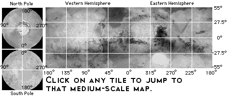
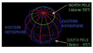
- Mars is split into four quadrants: North Pole, South Pole, Eastern Hemisphere, Western Hemisphere.
- Each quadrant can be viewed at three scales: big (lets you see the whole quadrant at once), medium (lets you see a region of Mars that's about the size of the continental US), and small (shows a region about the size of Wyoming, with a resolution of 0.95 kilometers per pixel).
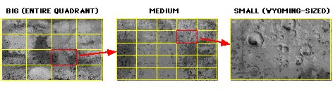
The East and West quadrants are divided into a 4 x 4 grid of medium-scale images. Each medium-scale image in turn is made up of a 5 x 5 grid of small-scale images.
Some shortcuts:
- Click on any low resolution map to zoom in and bring up a medium resolution map.
- Click on any medium resolution map to bring up the high resolution view.
- The small map (below) is a shortcut to any medium resolution map. Just click
in the rectangle you'd like to see.
- One nice feature of this web browser: If you click on an image and hold the
mouse down, you'll see a pop-up menu that lets you copy the image to the clipboard
or display it in its own window.